
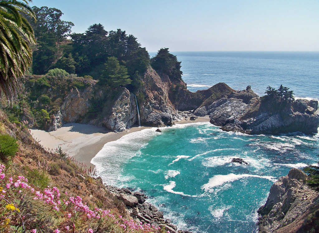
McWay Falls and Pfeiffer Beach are two of the most photographed spots on the entire Big Sur coast, and they’re only about ten miles apart on Highway 1 — which means most people try to do both in the same afternoon. The problem is that they don’t work anything alike. McWay Falls is a five-minute walk from a small paved lot right off the highway. Pfeiffer Beach is down a narrow, unmarked road that trips up half the people looking for it, with a parking lot that fills up fast. Treating them as one stop with one plan is how people end up circling for parking at one and missing the other entirely.
This is a straight logistics guide: where to park, what it costs, what’s actually open right now, and how to get both done in a single day without the stress.
McWay Falls: Parking, Fees, and What You’ll Actually See
McWay Falls sits inside Julia Pfeiffer Burns State Park, about 37 miles south of Carmel on Highway 1. The parking lot is small, paved, and right off the highway — easy to spot, easy to miss a space in on a busy weekend. Day-use costs $10 per vehicle, and the park is open from 8 a.m. to sunset. There’s an entrance station, but when it’s unstaffed you self-register and pay at the lot.
From the lot, the overlook is a flat, paved half-mile round trip — genuinely one of the easiest “big view” walks in all of Big Sur. The trail runs through a short tunnel under the highway, then opens onto the bluff where the falls drop into the cove below.
Here’s the part that surprises first-timers: you can’t get down to that beach. The cliffs around the cove are fenced off, and California State Parks flags the whole area as extremely hazardous — this isn’t red tape, it’s a real cliff situation. The beach itself is actually fairly new in geologic terms: a massive 1983 mudslide dumped millions of cubic yards of debris into the cove, and wave action shaped it into the sandy crescent you see today. So the view from the overlook is the visit. Budget 20 to 30 minutes, not a couple hours.
While you’re up there, look for the low stone foundation and the scattered palm trees near the overlook — that’s what’s left of a mansion that once stood on this exact spot before it was torn down in the 1960s. A small building nearby still displays the estate’s old Pelton wheel, a leftover piece of its private hydroelectric setup. Little details like that make the short walk worth lingering on.

Is Highway 1 Actually Open Right Now?
Worth addressing directly, since it’s genuinely changed the calculus for visiting this stretch of coast in 2026: the Timber and Plaskett Fires burned through this section of Big Sur over the summer, and for several weeks Julia Pfeiffer Burns State Park was fully closed. As of late September 2026, that’s resolved — Caltrans has Highway 1 open the whole way from Carmel to Cambria, and all evacuation orders and warnings tied to the fires have been lifted, with the Plaskett Fire sitting at 99% containment.
Two things are still worth knowing before you go. First, backcountry trails east of Highway 1 inside Julia Pfeiffer Burns State Park remain closed for fire-suppression and repair work — this doesn’t touch the McWay Falls overlook itself, which sits on the ocean side of the highway, but it does rule out any longer hike in the park right now. Second, there’s an unrelated construction zone at Rocky Creek Bridge (about 16 miles south of Monterey) running one-way controlled traffic 24/7 through the end of November 2026 — normal seasonal road work, not a closure, but expect a short wait if you hit it at the wrong moment. Conditions on this stretch of coast can still shift with weather or new fire activity, so a quick check of Caltrans’ Highway 1 status page the morning you leave is a five-minute habit worth keeping, especially outside of summer.
Pfeiffer Beach: Finding the Turnoff and Parking
This is where people actually get stuck. Pfeiffer Beach’s access road has no highway sign — a deliberate, decades-old choice, and it’s exactly why the beach still feels a little secret despite being famous. Look for Sycamore Canyon Road, a narrow paved turnoff on the ocean side of Highway 1, roughly across from the Big Sur Ranger Station and not far from the post office in the village of Big Sur. If you’re using GPS, search “Pfeiffer Beach” directly rather than the road name — most map apps route you correctly, but double-check you’re not being sent to Pfeiffer Big Sur State Park instead, which is a separate place a couple miles up the highway.
The road itself is about 2.2 miles of single-lane pavement with only a couple of pullouts for passing oncoming cars — go slow, and expect to reverse into a pullout occasionally during busy periods. It’s open to motor vehicles only; walking or biking the road itself isn’t allowed.
Once you’re at the lot: day use runs $15 per vehicle, hours are 9 a.m. to 8 p.m. year-round, and parking tops out around 65 spaces. That fills up fast on summer weekends and holidays — if you’re set on a specific sunset slot in peak season, plan to arrive with real cushion, not five minutes before. There are no restrooms and no potable water at the beach, just four picnic tables, so plan accordingly before you head down the access road. Dogs are welcome on a leash no longer than six feet.
One more thing worth knowing before you commit to the drive: after winter storms, Sycamore Canyon Road can close intermittently for repairs, so a quick status check is worth it if you’re visiting between December and April.

The Purple Sand (and Why It’s Actually Purple)
Pfeiffer Beach’s purple streaks aren’t a filter or a trick of the light — it’s garnet, a heavy mineral that washes down from the hillsides above the beach and gets sorted and concentrated by wave action. The garnet shows up strongest right after a big swell or a rain event, when fresh sediment gets pushed down and separated out on the sand. Look for it in swirled, streaky patches rather than a beach that’s uniformly purple — some visits it’s subtle, other times it’s genuinely striking, and that variability is just how the mineral deposits work, not a sign you’re in the wrong spot.

Keyhole Arch and the Famous Sunset “Fire” Photo
The other reason Pfeiffer Beach shows up on every California bucket list: Keyhole Arch, a large sea-carved rock formation just offshore with a hole punched clean through it. For most of the year it’s simply a dramatic piece of coastline. But for a short window in December and January, the setting sun lines up directly with the opening, and the surf blasting through the arch lights up gold and orange — photographers plan entire trips around this exact alignment, and it’s genuinely worth seeing in person if your timing lines up.

Outside that window, the arch is still a striking photo subject at any sunset, with the surf crashing through the gap and the rock silhouetted against the sky. Either way, watch your footing on the wet rocks near the arch and keep an eye on incoming waves — this stretch of the Pacific doesn’t give much warning before a sneaker wave, and the beach has no lifeguard.

Doing Both in One Day
The two stops pair naturally if you sequence them right. McWay Falls looks best in flat or midday light, when the sun actually reaches down into the cove and lights up that turquoise water — an overcast morning still works fine, but you lose some of the color. Pfeiffer Beach, on the other hand, is a sunset destination: the purple sand and the arch both photograph best in the last hour or two of daylight.
So the natural order is McWay Falls first — late morning or early afternoon — then Pfeiffer Beach for sunset. Coming from the north on Highway 1, that’s also the order you’ll hit them in geographically, so you’re not backtracking. Build in real slack for the Sycamore Canyon Road drive and the parking-lot wait at Pfeiffer Beach; treating either stop as a quick five-minute detour is exactly how people end up rushing the one part of the day — sunset at the arch — that’s genuinely worth not rushing.
Quick Answers
Can you pay by card, or do you need cash? Both lots take card at the self-registration kiosks, but Big Sur’s cell service is unreliable enough that carrying a little cash as backup isn’t a bad idea.
Can RVs or trailers make it down to Pfeiffer Beach? Officially there’s no posted length limit, but Sycamore Canyon Road’s single lane and tight turn make it a genuinely bad idea for anything long or wide. Leave the trailer at your campsite or hotel and drive down in the tow vehicle instead.
Can you swim at either spot? Not recommended at McWay Falls — there’s no beach access at all. Pfeiffer Beach has no lifeguards and a real rip-current risk; wading is common, swimming isn’t advised.
Is either stop wheelchair accessible? The McWay Falls overlook trail is paved and flat, which makes it one of the more accessible viewpoints on this stretch of coast. Pfeiffer Beach has an accessible parking area, but the beach itself is loose sand beyond the lot.
Where to Stay Nearby
Big Sur itself has very little lodging and what exists books up (and prices up) fast, especially in summer. Most people base themselves a bit further south instead — Cambria makes a solid, more affordable home base for exploring this stretch of coast without fighting for a same-night room in Big Sur proper. If McWay Falls and Pfeiffer Beach are just two stops on a longer Highway 1 run, they slot in naturally partway through a full Pacific Coast Highway road trip from San Francisco to Los Angeles, which covers the rest of the drive stop by stop.

Leave a Reply