
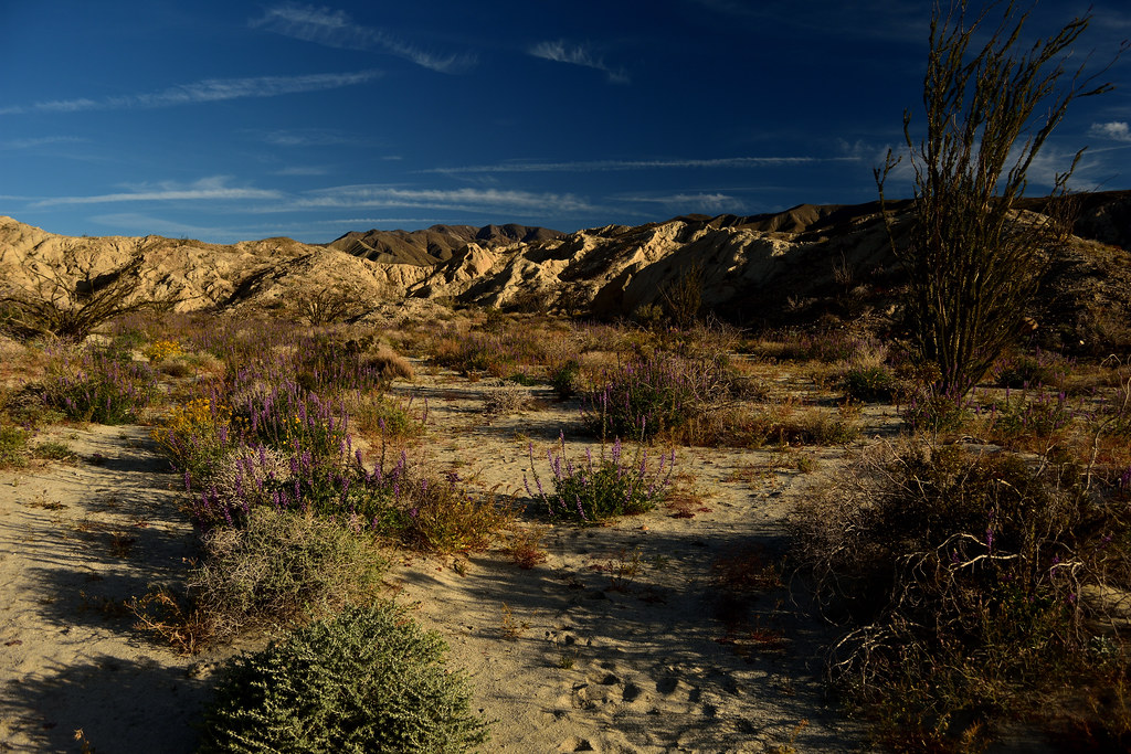
Every year, right around late winter, the same question starts circulating in California desert groups: is this the year for an Anza-Borrego super bloom? The honest answer is that nobody can tell you that in December, or even in most of January. The desert decides on its own schedule, and that schedule is set by rain that fell months earlier, not by a date on a calendar.
Quick answer: the realistic window for Anza-Borrego wildflowers runs from late February through early April, with the peak most often landing in mid-March — but that’s a historical pattern, not a guarantee. The only way to actually time a trip well is to check current bloom reports in the two or three weeks before you go, which this guide gets to below.
This article may contain affiliate links. If you book or buy through one, California Wanderer may earn a small commission at no extra cost to you. As an Amazon Associate I earn from qualifying purchases.
Why the timing moves around so much
Anza-Borrego’s wildflower season isn’t a fixed event like a festival with a set date. It’s a rain-triggered biological response. According to the Anza-Borrego Desert Natural History Association, wildflowers in the park “usually bloom between late February and early April, typically peaking in mid-March” — but that pattern only holds when winter rainfall cooperates. A wet winter means strong germination and a fuller, longer display. A dry one can mean a thin season, or in some years, close to no bloom at all in the lower desert.
Different species also follow their own internal clocks once the rain does arrive. Desert sand verbena, dune evening primrose, and desert sunflowers tend to show first, in February and March. Ocotillo — technically not a true wildflower, but the plant most people photograph here — typically blooms March into April. Palo verde trees and cacti follow in April, ironwood in May, and desert willow and smoke trees close out the season in June. That staggered timeline is part of why “when should I go” doesn’t have one single answer even within a single good year.
What a real season actually looks like: 2026 as a case study
The 2026 season is a useful illustration of how much a bloom can shift inside that general window — not a date to copy for a different year. Heavy rain through late 2025 had observers expecting a strong germination year, with peak bloom most likely landing in March or April. By early February, flowers were already widespread, with the heaviest concentration along Henderson Canyon Road near the Peg Leg Smith Monument. Reports through mid-to-late February described fuller displays on Henderson Canyon Road alongside sparser patches elsewhere, and warned that sustained heat in the upper 90s would shorten the whole thing.
That’s close to what happened, according to DesertUSA’s season-long bloom tracking: most areas were reported past peak by March 11. By March 27, heat had damaged much of what was left, and by early May the season was effectively over. The lesson isn’t the specific dates — it’s that a season can run its entire course, start to finish, in about ten weeks, and the back half of that window can close faster than the front half opened.
How to actually check before you drive out
Because the window is this narrow and this rain-dependent, don’t plan a wildflower trip to Anza-Borrego more than a couple of weeks out without checking current conditions first. A few sources are worth checking in the week or so before you go:
- The Anza-Borrego Desert Natural History Association’s bloom updates are the closest thing to an official, park-adjacent source, with dated posts on what’s actually flowering and where.
- DesertUSA’s desert bloom blog tracks the season closely across multiple Southern California desert parks, not just Anza-Borrego, and is useful for comparing how this year stacks up.
- The official Anza-Borrego Desert State Park page is the place to check for closures, fire restrictions, and visitor center hours before you commit to a drive.
None of these can tell you what next year’s bloom will look like in January. What they can tell you, reliably, is what’s actually blooming right now — which is the only question that matters once you’re deciding whether to make the drive this weekend.

Where to actually see it once you’re there
Three spots cover most of what a first-time wildflower visitor is after, and they don’t require serious hiking to reach.
Henderson Canyon Road and DiGiorgio Road, on the north side of Borrego Springs, are where roadside sand verbena and desert poppy displays tend to concentrate in a good year — the kind of drive-and-pull-over wildflower viewing most visitors actually picture. Ocotillo, blooming later in the season than the annual wildflowers, shows up along roadsides and open desert throughout the park from March into April, with its red tubular flower clusters at the tip of each spiny cane.
Borrego Palm Canyon, reached via a moderate out-and-back trail from the park’s main campground, leads to a California fan palm oasis — one of the largest native palm groves in the United States. It’s a legitimately different kind of desert scenery than the open wildflower fields, and worth building into the same trip. One honest caveat: the first palm grove along this trail has been recovering from fire damage, so check current trail conditions at the visitor center before you go in expecting the full grove experience.

Fonts Point, reached by a sandy spur road off S22, is the park’s classic badlands overlook — a cliff-edge view across the Borrego Badlands that’s dramatic with or without flowers, and sits near desert lily colonies in a good bloom year. The access road is unpaved and soft in places; a standard car can usually make it in dry conditions, but it’s worth asking locally if there’s been recent rain.

One access note worth knowing before you plan a backcountry route: Coyote Canyon Dirt Road has had a long-standing closure to vehicle traffic between Lower Willows and Middle Willows, dating back to flood damage from Tropical Storm Hilary in 2023. Hikers, cyclists, and equestrians can still use that section — it’s just closed to vehicles at the Lower Willows gate. It doesn’t affect Borrego Palm Canyon, Henderson Canyon Road, or Fonts Point, but if a deeper Coyote Canyon route is part of your plan, confirm its current status on the park’s own alerts page before you go, since conditions like this can change (this closure was still posted as of the park’s most recent update at the time of writing).
What to actually expect, conditions-wise
“Wildflower season” at Anza-Borrego still means desert conditions, not a mild spring stroll. A few things worth knowing before you go:
- Heat shows up faster than the calendar suggests. Afternoon temperatures in the 90s aren’t unusual even during peak bloom weeks, and that heat is exactly what ends the season early in a given year.
- Cell service is unreliable through most of the park. Don’t count on your phone for navigation or emergencies once you’re off the main highway.
- Carry real water, not a water bottle’s worth. The park’s own guidance is at least a gallon per person per day in warm conditions — easy to undershoot if you’re planning a full day of stops.
- Rattlesnakes become active in March and April, right in the middle of peak bloom season. Stay on established trails and roads.
- Leave the flowers where they are. Photograph them, don’t pick them or walk off-trail to get closer — the plants and the soil crust around them are both easy to damage and slow to recover.
What to Pack for an Anza-Borrego Wildflower Trip
- a lightweight UPF sun hoodie — there’s rarely any shade along the roadside wildflower stops, and a lightweight long-sleeve layer beats reapplying sunscreen every hour.
- a wide-brim sun hat — the Fonts Point overlook and the open stretches of Henderson Canyon Road have zero natural shade, and a wide brim does more than a cap for your neck and ears.
- a hydration backpack — with cell service unreliable and the park’s own guidance running a gallon per person per day, a hands-free hydration setup makes it a lot easier to actually hit that number on the Borrego Palm Canyon trail.
Basing out of Palm Springs?
Anza-Borrego sits roughly an hour and a half from the Palm Springs area by car, which makes it a realistic day trip if you’re already staying in the Coachella Valley rather than Borrego Springs itself. If that’s your situation, California Wanderer’s guide to the best day trips from Palm Springs covers how a desert-loop day like this fits alongside the area’s other options.
The bottom line
There’s no single date that works every year — that’s the one thing every real source on this agrees on. The realistic planning window is late February through early April, the historical peak is mid-March, and the only way to actually catch it is to check current reports in the two or three weeks before you go, not to pencil in a date months in advance and hope.
Leave a Reply