
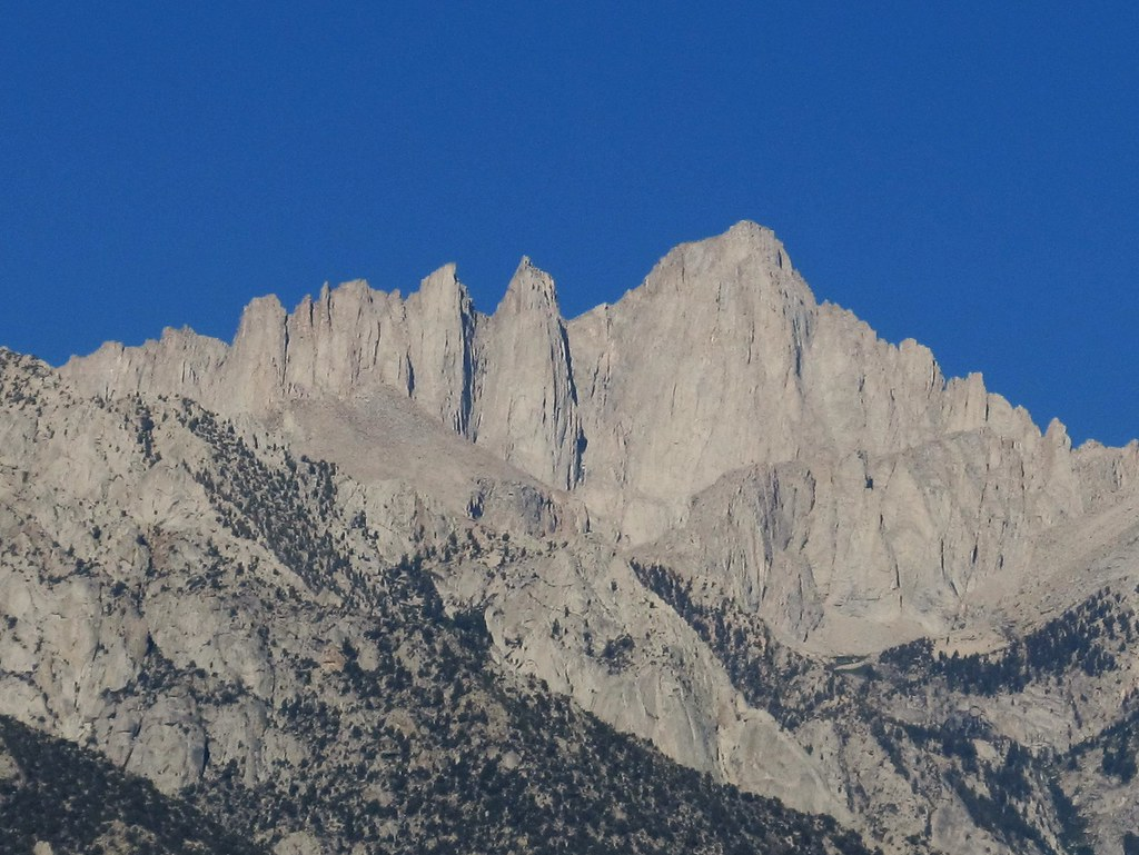
Everyone searching “Mount Whitney permit” ends up reading about the lottery: the dates, the odds, how many names go in. Almost nobody explains what happens afterward — what a walk-up permit at the visitor center actually involves, where you’re supposed to park at 2 a.m., or how to train for 6,100 feet of gain at altitude instead of just training for 22 miles. That’s the part that actually determines whether your hike works.
This article may contain affiliate links. If you book or buy through one, California Wanderer may earn a small commission at no extra cost to you. As an Amazon Associate I earn from qualifying purchases.
Quick answer: The Mount Whitney lottery runs February 1–March 1 on Recreation.gov, with results posted March 15. If you don’t win, unclaimed permits open first-come on April 22, and a smaller number of walk-up permits become available the day before any given entry date at the Eastern Sierra Interagency Visitor Center in Lone Pine. A wilderness permit is required in the Whitney Zone every day of the year, quota season or not.
How the Mount Whitney permit lottery actually works
The Mount Whitney Trail sits inside a quota area, and getting past that quota is the entire first problem to solve. Applications open February 1 and close March 1 on Recreation.gov, and the system is a true lottery — applying on day one doesn’t improve your odds over applying on day 28. What does help is listing more acceptable entry dates on your application, since a flexible date range has more quota slots to land in than a single fixed day.
Results post to your Recreation.gov account on March 15. If you’re awarded a permit, you have until April 21 to accept it and pay the $15-per-person recreation fee — miss that window and your slot goes back into the pool. There’s also a non-refundable $6 reservation fee charged when you apply, win or lose, so a scattershot application strategy has a real cost.
Quota season runs May 1 through November 1. Outside that window, the quota goes away, but the permit requirement doesn’t — Forest Order 05-04-55-25-01 prohibits recreating in the Whitney Zone without one, any day of the year. The daily cap during quota season is commonly cited as roughly 100 day-use and 60 overnight permits, though Recreation.gov’s own listing doesn’t publish an exact number — treat that figure as a useful planning estimate, not a guarantee.

Didn’t win the lottery? Here’s what a walk-up permit actually takes
This is the part most guides skip entirely. When winners don’t claim their permits by April 21, or no-show without printing them, those slots don’t just vanish — they go back into circulation. The first wave releases April 22 at 7 a.m. Pacific on Recreation.gov, first-come, and it’s worth setting a calendar reminder if your preferred dates didn’t come through the lottery.
Closer to your actual hiking date, there’s a second path: unclaimed and cancelled permits get released as free walk-in permits at the Eastern Sierra Interagency Visitor Center, a mile south of Lone Pine on Highway 395. By most accounts, these go out starting around 11 a.m. the day before your intended entry date, with no permit fee attached. It’s a real option, not a rumor — but it’s also genuinely unreliable. The hikers who land one are usually the ones already in Lone Pine a day or two early, not people who drove in that morning hoping for the best. If you’re traveling any real distance to hike Whitney, don’t build a trip around a walk-up permit as your only plan — call the visitor center ahead of time to confirm the day’s availability before you commit.

Whitney Portal: parking, camping, and the bears
Whitney Portal sits at the end of Whitney Portal Road, about 13 miles west of Lone Pine, at 8,360 feet. The trailhead itself has day-use parking, but it’s worth knowing this is a working trailhead for both day hikers and backpackers sharing the same small lot — arrive early, especially on a summer weekend, and don’t assume a spot waiting for you at sunrise.
If you’re staying overnight before or after your hike, Whitney Portal Campground is the only reservable option — 43 sites at $34 per night plus $10 for an additional vehicle, bookable through Recreation.gov or by phone. It typically runs late May through mid-October, sits at 8,100 feet, and every site has a bear-proof locker — food, trash, and anything scented has to go in it, not your car. Bears here are genuinely active and known to break into vehicles that don’t store food properly, not just a generic warning sign nobody takes seriously.
One logistics detail that trips people up: a WAG bag (a human-waste disposal kit) is required on the trail year-round, and you’re expected to pack your waste out to the marked receptacle near the Portal restroom. They’re free at the Lone Pine Ranger Station, about 2 miles south at the junction of Highways 395 and 136 — grab one there before you drive up, since the ranger station gates overnight and the after-hours self-issue kiosk isn’t guaranteed to be stocked.
Training for the altitude, not just the mileage
Mount Whitney’s day-hike route is about 22 miles round trip with roughly 6,100 feet of elevation gain, topping out at 14,505 feet. Most people training for it focus entirely on distance and miss the part that actually ends hikes early: altitude.
Symptoms of acute mountain sickness can show up hours after you’d expect — feeling fine at Trail Crest (around 13,600 feet) doesn’t mean you’re in the clear. If symptoms do hit, descending and recovering can take far longer than planned, which is exactly how a “day hike” turns into an unplanned night out. Roughly half of permit holders who attempt Whitney actually reach the summit, and altitude — not fitness — is usually the reason the other half turns back.

A sensible training approach, widely recommended by experienced Whitney hikers: build toward Whitney over 3–5 months with cardio three or more times a week, progressive weekly mileage that peaks with a few 15+ mile training hikes, and strength work (squats and lunges in particular) two to four times a week. In the five weeks directly before your hike, get real elevation exposure — training hikes above 11,000, 12,000, and even 13,000 feet, if you can reach them, matter more than flat mileage at sea level. There’s no substitute for having your body already know what thin air feels like before summit day.
What hike day actually looks like

Most day hikers start absurdly early — midnight to 2 a.m. is standard, not an outlier — both to beat the heat on the lower switchbacks and to be off any exposed ridgeline before afternoon thunderstorms build, which they reliably do in summer. You won’t be alone on the trail at that hour; Whitney draws a crowd, which helps with route-finding in the dark but isn’t a substitute for your own navigation and judgment. Cell coverage is largely absent above the trailhead, and help, if you need it, usually means another hiker or a ranger happening to be nearby — not a quick call.
The trail itself climbs through forest and past Trail Camp (about 12,000 feet, the last reliable water before the summit push), then switchbacks up to Trail Crest before a final, mostly-flat but exposed ridge walk to the summit. Expect to use your hands scrambling over granite in a few spots. Bring a water filter or treatment — there’s enough water along the route to refill rather than carry all 22 miles’ worth from the start.

What to Pack for a Mount Whitney Day Hike
- a reliable headlamp with spare batteries — most hikers start in the dark, and a weak or dying light is a genuine hazard on switchbacks and exposed granite.
- a lightweight water filter or treatment — Trail Camp is the last reliable water source before the summit push, so a way to treat it on the spot beats carrying 22 miles of water from the trailhead.
- a packable insulated layer — temperatures swing hard between a midnight trailhead start and an exposed, windy 14,505-foot summit; one warm layer that packs small is worth more than a heavier jacket you leave in the car.
Mount Whitney permit FAQ
Do I need a permit even for a short walk partway up the trail?
Yes, within the Whitney Zone the permit requirement applies regardless of how far you actually plan to go — it’s tied to entering the zone, not reaching the summit.
Can I transfer or sell my permit to someone else?
No. Permits can’t be sold or transferred, and there are no refunds or credits if your plans change.
What if I need to change my date after winning?
You can request a date change online if you do it at least 12 days before your entry date and quota is still available for the new date — it isn’t guaranteed.
Is Mount Whitney the only Sierra peak with a lottery system like this?
No — Yosemite’s Half Dome runs its own separate cable-permit lottery, with different dates, fees, and rules entirely. If that’s also on your list, it’s worth reading it as its own system rather than assuming Whitney’s dates apply: see California Wanderer’s Half Dome permit lottery guide for how that one actually works.
What’s the best time of year to go?
July through September is the usual window, when the trail is typically snow-free and daytime temperatures are the most manageable. Outside that range, you’re likely dealing with snow and ice, which turns this from a hike into a mountaineering trip requiring different gear and skills entirely.

Leave a Reply